Forts of Madison County
ALTON BLOCKHOUSE
1812, Exact location unknown.
A settler’s blockhouse.
BARTLETT’S FORT, OR JOSEPH BARLETT’S BLOCKHOUSE
Built by Joseph Bartlett during the War of 1812-14, Pin Oak Township
A settlers’ blockhouse, stood until 1834, when it was moved and
converted to stables. Bartlett was the first treasurer of Madison
County.
BECK’S BLOCKHOUSE
1811, 1831, near Edwardsville
A settlers’ fort located on John Beck’s farm, 3 miles east of
Edwardsville. Rebuilt during the 1831 Sauk War.
(JAMES) BEEMAN, OR MILTON FORT
1811. Section 21 in Wood River Township.
A settlers’ fort constructed in 1811, about a mile south of the old
town of Milton. Jacob Preuitt, son of Solomon Preuitt, was born in
this fort. This birth was among the first in the township. James
Beeman was a member of the Vaughn Hill Baptist Church, where Abel
Moore and family were members. James married Nancy Moore, sister of
Abel Moore. Beeman was appointed to get plank to floor the church
house, and get two acres of land from Joseph Vaughn for a church and
graveyard.
BRAZIL’S STATION
1810
A settlers’ fort located on Terrapin Ridge, five miles from
Shelton’s Fort.
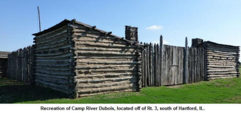
CAMP RIVER DUBOIS
1803-1804, Near the Wood River
A stockade winter encampment with four cabins, located near the
mouth of the Wood River (River DuBois). This was the departure point
for the Lewis & Clark Expedition, May 1804.
(CAPTAIN NATHAN) CHAMBERS’ FORT
1811, Summerfield
A settlers’ fort located one mile south of town near a branch of
Silver Creek on the western edge of Looking Glass Prairie. Area
known as Union Grove at the time.
CHILTON’S FORT
1810-1812, Two miles west of St. Jacob. East side of Silver Creek
A settlers’ blockhouse, located about two miles west of town. Never
attacked. Also known as Fort Augusta. Site most likely destroyed
during highway construction in the 1980s. The families of John
Lindley, Augustus Chilton, William Chilton, Cyrus Chilton, Harrison,
Smeltzer, Howard, and Husers all took shelter in Chilton’s Fort
during the War of 1812-14. David Smeltzer taught schools in
Chilton’s Fort.
DOWNINGS FORT
1810? Near the border of Madison/St. Clair Counties, in Jarvis
Township
A settlers’ fort, located somewhere in the southern part of the
county.
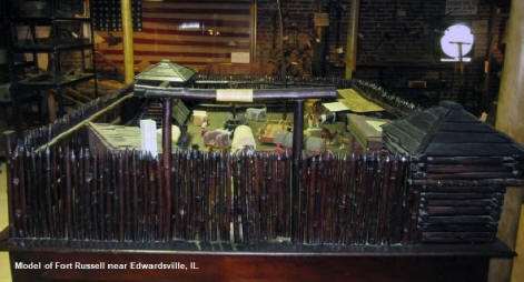
FORT BUTLER
1812, St. Jacob
A settlers’ fort and refuge for 11 families. Never attacked.
FORT RUSSELL
Built in 1812, Near Edwardsville.
This five-gun stockade blockhouse was the headquarters for Governor
Ninian Edwards and main supply depot for the Territorial militia.
The Governor opened his court at the fort, and presided with “genius
and talent.” The cannon of Louis XIV of France were taken from old
Fort Chartres, and taken to Fort Russell. The fort was named in
honor of Colonel William Russell of Kentucky, who had command of the
ten companies of Rangers to defend the western frontier. Four
companies were allotted to the defense of Illinois, and were
commanded by William B. Whiteside, James B. Moore, Jacob Short, and
Samuel Whiteside. A small company of Regulars, under the command of
Captain Ramsey, were stationed at Fort Russell for a few months
during 1812.
(JOHN) GILLHAM’S FORT
Section 1, Chouteau Township
A stockade fort built near the homes of John Gillham and his five
sons, three brothers by the name of Brown, three Kirkpatricks, and
families by the name of Dunnagan, Sanders, Ferguson, Dodd, Revis,
Beeman, Winsor, Celver, Green, and Smith. According to S. P.
Gillham, an early pioneer, the fort was constructed on Section 1,
township 4, Range 9, 3rd principal merdian in Chouteau Township. In
1875, Mr. L. Southard lived on the spot where the fort had been.
HARTFORD FORT
1812, near Hartford
A settlers’ fort located opposite the mouth of the Missouri River.
HAYES BLOCKHOUSE
1812, Nameoki Township
A settlers’ blockhouse located in the American Bottom.
(NAT) HILL’S FORT
1812, near Pierron
A settlers’ fort located a few miles above the mouth of Goshen
(Doza) Creek, on the east side of the creek, east of town.
JONES’ FORT
1807, near Edwardsville
A settlers’ fort north of town, probably near Indian Creek.
(FRANK) KIRKPATRICK’S FORT
1811, near Edwardsville
A settlers’ blockhouse, located southeast of town, east of brother
James’ fort.
(JAMES) KIRKPATRICK FORT
1811, near Edwardsville
A settlers’ blockhouse, located 2-3 miles southwest of town, Brother
to Frank and Thomas.
(THOMAS) KIRKPATRICK FORT
1811, Edwardsville
A settlers’ blockhouse located 300 yards from Cahokia Creek at the
end of present-day O Street, just off of North Main Street. He was a
brother to James and Frank.
LOFTON’S BLOCKHOUSE
1812, Nameoki Township
A settlers’ blockhouse located in the American Bottoms.
(GEORGE) MOORE’S BLOCKHOUSE
1808, Northwest quarter of section 10 in Wood River Township.
A settlers’ blockhouse
PREUITT’S BLOCKHOUSE
1812-1817
A settlers’ blockhouse. Unknown location. Dismantled in 1817 and
sold for lumber.
(WILLIAM or T. J.) SHELTON’S FORT
1809 - 1812
A settler’s fort located on Silver Creek
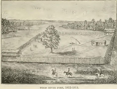
WOOD RIVER FORT
1812, Section 10 of Wood River Township
A settlers’ fort
Captain Toliver Wright, who settled near the mouth of the Wood River
in 1806, served as Ranger during the War of 1812-14. While in
command, he was shot by an Indian, carried back to the Wood River
Fort, and died six weeks later. On the night of the Wood River
Massacre, July 10, 1814, local families fled to this fort for
protection.